
Demonstration Provides First Look at Texas Disaster Information System
Innovative collaboration will mitigate flood risks and protect Texas communities
AUSTIN — AUSTIN, Texas — In recognition of the start of the 2022 Hurricane Season, the Texas General Land Office (GLO), Texas A&M University’s (TAMU) Institute for a Disaster Resilient Texas (IDRT), and the University of Texas (UT) led an exclusive preview demonstration of the Texas Disaster Information System (TDIS) in San Antonio. In a first-of-its-kind collaboration, TDIS will bring together all of the state’s natural hazard data into a dynamic online system to be useful for state agencies, city planners, first responders, emergency managers and the general public. TDIS will include everything from stream flows and topographical information to socioeconomic and demographic data.
“The Texas Disaster Information System will be an incredible tool for improving preparedness, response, recovery, and mitigation efforts across the state of Texas,” said Texas Land Commissioner George P. Bush. “This interactive, web-based data system will provide the most current and accurate information available, enabling community leaders, academic institutions, and the public at large access to assess valuable information related disaster risks, impacts, and mitigation strategies. This project is a tremendous example of what federal and state partners can accomplish working together to improve the lives of all Texans.”
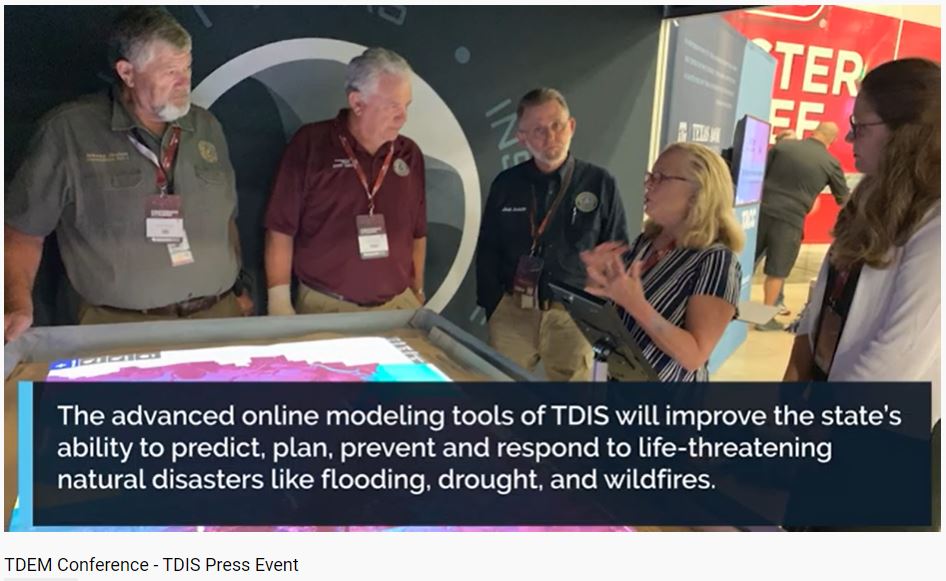
The event was led by project lead Sam Brody, Ph.D., director of IDRT, and Heather Lagrone, Senior Director of Disaster Recovery at the GLO. It included a demonstration of TDIS’s future capabilities, currently under development, using SimTable technology, a specialized table-mounted sandbox that projects flood simulations on a sample landscape to demonstrate what happens during a flood. The SimTable modeled Orange County flood events with special guests, Judge John Gothia, Commissioner Johnny Trahan and Emergency Management Coordinator Joel Ardoin. The simulation demonstrated the capabilities TDIS will soon make available for the public online. Dr. Liv Haselbach with Lamar University’s Center for Resiliency coordinated the Orange County data and ran the simulation. At the event Judge Gothia spoke about a retention ditch improvements project in Orange County in development using local data collected for the project. “"With a tool like this, that is able to show this kind of data, would really help us to evaluate and justify the cost of projects,” said Judge John Gothia. “For leaders such as myself in Orange, Jasper and Newton Counties, this is a game changer.”
“Previously, data was fragmented, siloed, and difficult to combine to see the bigger picture,” said Sam Brody, Ph.D., director of the Institute for a Disaster Resilient Texas and a lead on the project. “We are creating a system that is collecting the best data, making it permanent, interactive, and sharable – then building on top of it the best decision support tools that the best minds at universities can create. TDIS is a vision that we are implementing right now. It is going to help decision makers see the big picture instantly and help them make better decisions in preparing, response, planning, and recovery, and most importantly, it is going to save lives.”
The GLO partnered with TAMU, IDRT, and UT, as well as other state and federal partners, to design the advanced online modeling tool to improve the state’s ability to predict, plan, prevent and respond to life-threatening natural disasters like flooding, drought and wildfires. The GLO is providing $12.4 million to design and implement the system as well as an additional $30 million for the execution and maintenance of the system. The collaborating agencies have been laying the groundwork over the past year.
While partnering with the creation of TDIS, the GLO is concurrently conducting the Combined River Basin Flood Studies, which will result in detailed flood risk information and mitigation strategies for the counties that received a presidential disaster declaration due to the impact of Hurricane Harvey and severe flooding in 2015. TDIS will house the critical flood risk data and information collected through this study.
Researchers are working closely with other state and federal partners, including the Federal Emergency Management Agency and the U.S. Army Corps of Engineers, among others, to ensure the portal will provide useful tools that are easy to access during a disaster.
The open-source, web-based portal will be interactive and constantly updated with the most current data, allowing users to conduct complex analyses quickly. Decision-makers without a scientific background will be able to create and access maps and visualizations to help with everything from planning infrastructure investment to conducting emergency evacuations.
The Texas Disaster Information System is hosted by the new Institute for a Disaster Resilient Texas (IDRT), which the Texas A&M University System Board of Regents established in May of 2020 following the passage of House Bill 2345, which included dozens of policy recommendations in response to Hurricane Harvey, the costliest natural disaster in the state’s history. The institute, which is located on Texas A&M University at Galveston campus, looks to university experts to deliver critical research that will reduce risks from disasters and help Texas communities respond to climate-related emergencies.
TDIS will be powered by UT’s Texas Advanced Computing Center (TACC), which hosts one of the fastest supercomputers in the world. UT research scientists are creating the technical backbone of the system, while Texas A&M will contribute its unique knowledge about how to respond to and prepare for disasters, particularly flooding. The TDIS team, which also includes researchers from Rice University, Lamar University, and The University of Texas at San Antonio, will begin its work looking at issues related to flooding but will expand to address other hazards in the future, including hurricanes, fires and drought. One of its first outputs will be a statewide damage plain map that uses flood loss data provided by insurance companies to show areas at greatest flood risk, which will help homebuyers decide where to purchase property and assist city governments in deciding where to invest resources to protect against flooding.
For more information, please visit idrt.tamug.edu/tdis.
More Press Releases