


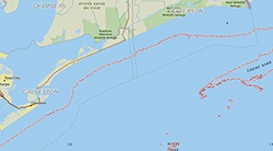
Boundaries of pre-approved area for use of dispersant in oil spill response. Boundaries were created by combining the 10-meter offshore bathymetric contour and the three nautical mile line. The boundary follows whichever line is farthest offshore. Data are not to be used for navigation or for mapping at large scales.