


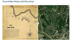
Texans have long turned to the Texas General Land Office (GLO) for maps and other tools used to display and organize information about the state’s rich natural resources. Since 2014, one such GLO initiative is Texas Hidden History (THH), a collaborative project between the GLO’s Archives and Records and Geospatial Technology Services Team. In 2020 the initiative was expanded to use Esri GIS software to produce narrative StoryMaps on Texas History topics that align with GLO collections strengths.